|
Specs?
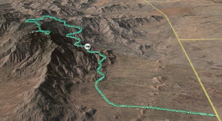
12 miles, climbing 3560 ft (1085m). Dead end road (built to transport massive telescopes) tops out at 6795 ft (2071m). |

[Photo courtesy of Jim Montgomery.] |

{Click on the picture for a larger image.] As you can see, the 12 mile road to the observatories at the top rises gently at first. A right hander, then it starts climbing properly. An excellent test of fitness. It took me 1:30, which means I lost considerable bike-specific fitness during my travels despite running and swimming nearly every day. No faking out the mountain. Brutually revealing. 1:15 would have been a good time (for me). The bumpy descent (20 mins) turned out also to be a good test of the Magellan GPS receiver. It switched off by itself on the descent. The tracklog shown above is from the climb.
Update: Unfortunately, the eXplorist 600 seems hosed. Have to send it back to Magellan to see if it can be repaired. With PacTour Elite Transcontinental only one week away, that's not enough time, plus it's already way out of warranty. I ordered a Garmin Vista Cx on Monday. Hope to get it Wednesday.

No comments:
Post a Comment