Had to look long and hard for my custom bicycling shoes, primary (Di Notte) and backup (Blackburn Flea) lighting. Yep, it has been so long I've forgotten where I stash my bike gear. Other fumbles were I had to use primary AA cells in my Di Notte headlight, my NiMh rechargeables were 6 hours away from being recharged. My Powercontrol head unit from the SRM powermeter was not taking a charge. I hate when I have to send that overpriced unit back to Colorado for servicing. Damn, have to do without data for this commute. Mind you, it's probably a blessing I don't see the numbers.
Temperatures were in the mid-90s to 100F (about 35C-38C). About 32 miles round-trip. Listened to Squeeze on my tiny new iPod Nano (6th generation) on the trip down. Showered at the gym and went to work.
However, by about 5pm, I was suddenly seized by what I thought was a mid-afternoon malaise. Downed two espressos from my Nespresso machine in my office. Headed out the door at 6. Suddenly I noticed I was crawling along in my small chainring. I diagnosed a delayed bonk. Stopped at a Circle-K, downed a 32oz gatorade, and resumed pedaling towards the foothills. But things didn't get better. In fact, they got quite a bit worse. I had to climb in my 34 x 26 gear on a moderate but long hill. I revised my diagnosis to be dehydration and electrolyte depletion.
That night, I threw up. Next day, I had an all day headache and high fever. Couldn't hold solid food. Lost a kilo.
I guess it was the Bicycling Gods way of punishing me for being off the bike so long. To be humbled on your own commute.
It's funny, I never expected to have problems completing the commute since I kept it simple and just spun, never encountering an aerobically-challenged moment during the commute. But I only had iced water, nothing to replace the electrolytes. Not a smart thing to do when it's still effectively summer, temperature-wise. Also having run 10K on the treadmill the previous evening probably didn't allow my muscles enough time to fully replenish its glycogen stores.
Had to look long and hard for my custom bicycling shoes, primary (Di Notte) and backup (Blackburn Flea) lighting. Yep, it has been so long I've forgotten where I stash my bike gear. Other fumbles were I had to use primary AA cells in my Di Notte headlight, my NiMh rechargeables were 6 hours away from being recharged. My Powercontrol head unit from the SRM powermeter was not taking a charge. I hate when I have to send that overpriced unit back to Colorado for servicing. Damn, have to do without data for this commute. Mind you, it's probably a blessing I don't see the numbers.
Temperatures were in the mid-90s to 100F (about 35C-38C). About 32 miles round-trip. Listened to Squeeze on my tiny new iPod Nano (6th generation) on the trip down. Showered at the gym and went to work.
However, by about 5pm, I was suddenly seized by what I thought was a mid-afternoon malaise. Downed two espressos from my Nespresso machine in my office. Headed out the door at 6. Suddenly I noticed I was crawling along in my small chainring. I diagnosed a delayed bonk. Stopped at a Circle-K, downed a 32oz gatorade, and resumed pedaling towards the foothills. But things didn't get better. In fact, they got quite a bit worse. I had to climb in my 34 x 26 gear on a moderate but long hill. I revised my diagnosis to be dehydration and electrolyte depletion.
That night, I threw up. Next day, I had an all day headache and high fever. Couldn't hold solid food. Lost a kilo.
I guess it was the Bicycling Gods way of punishing me for being off the bike so long. To be humbled on your own commute.
It's funny, I never expected to have problems completing the commute since I kept it simple and just spun, never encountering an aerobically-challenged moment during the commute. But I only had iced water, nothing to replace the electrolytes. Not a smart thing to do when it's still effectively summer, temperature-wise. Also having run 10K on the treadmill the previous evening probably didn't allow my muscles enough time to fully replenish its glycogen stores.
Showing posts with label bike. Show all posts
Showing posts with label bike. Show all posts
Saturday, September 18, 2010
Back on the bike
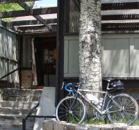
It has been about a year and a half off my bike. Last week, I decided to bike commute instead of driving. Hence the bike-specific Trek pack with back ventilation (holding work clothing).
 Had to look long and hard for my custom bicycling shoes, primary (Di Notte) and backup (Blackburn Flea) lighting. Yep, it has been so long I've forgotten where I stash my bike gear. Other fumbles were I had to use primary AA cells in my Di Notte headlight, my NiMh rechargeables were 6 hours away from being recharged. My Powercontrol head unit from the SRM powermeter was not taking a charge. I hate when I have to send that overpriced unit back to Colorado for servicing. Damn, have to do without data for this commute. Mind you, it's probably a blessing I don't see the numbers.
Temperatures were in the mid-90s to 100F (about 35C-38C). About 32 miles round-trip. Listened to Squeeze on my tiny new iPod Nano (6th generation) on the trip down. Showered at the gym and went to work.
However, by about 5pm, I was suddenly seized by what I thought was a mid-afternoon malaise. Downed two espressos from my Nespresso machine in my office. Headed out the door at 6. Suddenly I noticed I was crawling along in my small chainring. I diagnosed a delayed bonk. Stopped at a Circle-K, downed a 32oz gatorade, and resumed pedaling towards the foothills. But things didn't get better. In fact, they got quite a bit worse. I had to climb in my 34 x 26 gear on a moderate but long hill. I revised my diagnosis to be dehydration and electrolyte depletion.
That night, I threw up. Next day, I had an all day headache and high fever. Couldn't hold solid food. Lost a kilo.
I guess it was the Bicycling Gods way of punishing me for being off the bike so long. To be humbled on your own commute.
It's funny, I never expected to have problems completing the commute since I kept it simple and just spun, never encountering an aerobically-challenged moment during the commute. But I only had iced water, nothing to replace the electrolytes. Not a smart thing to do when it's still effectively summer, temperature-wise. Also having run 10K on the treadmill the previous evening probably didn't allow my muscles enough time to fully replenish its glycogen stores.
Had to look long and hard for my custom bicycling shoes, primary (Di Notte) and backup (Blackburn Flea) lighting. Yep, it has been so long I've forgotten where I stash my bike gear. Other fumbles were I had to use primary AA cells in my Di Notte headlight, my NiMh rechargeables were 6 hours away from being recharged. My Powercontrol head unit from the SRM powermeter was not taking a charge. I hate when I have to send that overpriced unit back to Colorado for servicing. Damn, have to do without data for this commute. Mind you, it's probably a blessing I don't see the numbers.
Temperatures were in the mid-90s to 100F (about 35C-38C). About 32 miles round-trip. Listened to Squeeze on my tiny new iPod Nano (6th generation) on the trip down. Showered at the gym and went to work.
However, by about 5pm, I was suddenly seized by what I thought was a mid-afternoon malaise. Downed two espressos from my Nespresso machine in my office. Headed out the door at 6. Suddenly I noticed I was crawling along in my small chainring. I diagnosed a delayed bonk. Stopped at a Circle-K, downed a 32oz gatorade, and resumed pedaling towards the foothills. But things didn't get better. In fact, they got quite a bit worse. I had to climb in my 34 x 26 gear on a moderate but long hill. I revised my diagnosis to be dehydration and electrolyte depletion.
That night, I threw up. Next day, I had an all day headache and high fever. Couldn't hold solid food. Lost a kilo.
I guess it was the Bicycling Gods way of punishing me for being off the bike so long. To be humbled on your own commute.
It's funny, I never expected to have problems completing the commute since I kept it simple and just spun, never encountering an aerobically-challenged moment during the commute. But I only had iced water, nothing to replace the electrolytes. Not a smart thing to do when it's still effectively summer, temperature-wise. Also having run 10K on the treadmill the previous evening probably didn't allow my muscles enough time to fully replenish its glycogen stores.
Had to look long and hard for my custom bicycling shoes, primary (Di Notte) and backup (Blackburn Flea) lighting. Yep, it has been so long I've forgotten where I stash my bike gear. Other fumbles were I had to use primary AA cells in my Di Notte headlight, my NiMh rechargeables were 6 hours away from being recharged. My Powercontrol head unit from the SRM powermeter was not taking a charge. I hate when I have to send that overpriced unit back to Colorado for servicing. Damn, have to do without data for this commute. Mind you, it's probably a blessing I don't see the numbers.
Temperatures were in the mid-90s to 100F (about 35C-38C). About 32 miles round-trip. Listened to Squeeze on my tiny new iPod Nano (6th generation) on the trip down. Showered at the gym and went to work.
However, by about 5pm, I was suddenly seized by what I thought was a mid-afternoon malaise. Downed two espressos from my Nespresso machine in my office. Headed out the door at 6. Suddenly I noticed I was crawling along in my small chainring. I diagnosed a delayed bonk. Stopped at a Circle-K, downed a 32oz gatorade, and resumed pedaling towards the foothills. But things didn't get better. In fact, they got quite a bit worse. I had to climb in my 34 x 26 gear on a moderate but long hill. I revised my diagnosis to be dehydration and electrolyte depletion.
That night, I threw up. Next day, I had an all day headache and high fever. Couldn't hold solid food. Lost a kilo.
I guess it was the Bicycling Gods way of punishing me for being off the bike so long. To be humbled on your own commute.
It's funny, I never expected to have problems completing the commute since I kept it simple and just spun, never encountering an aerobically-challenged moment during the commute. But I only had iced water, nothing to replace the electrolytes. Not a smart thing to do when it's still effectively summer, temperature-wise. Also having run 10K on the treadmill the previous evening probably didn't allow my muscles enough time to fully replenish its glycogen stores.

Sunday, September 7, 2008
SRAM Red 11-26 cassette
I used to be really into getting the latest and greatest components for my road bike. It was kind of a hobby of mine. An expression of my love for cycling as it were.
Now, I simply ride my bike and enjoy the scenery.
(See last entry on the matter here.) However, recognizing that I no longer had the legs to ride a 23T up Mt Lemmon (even on a compact crank setup), I installed an SRAM Red 11-26 cassette this weekend. And it immediately took me back to my bike porn days. I grabbed my DSLR to illustrate why before it got all greasy and encrusted with dirt:
Not only that it's a specially-made 10-speed steel cassette that is hollowed out to the point it weighs just 168g as measured on my scale (see below) but the fact that it comes in a (function-free) soft red bag is proof-positive this is a serious piece of chi-chi componentry.
Lightweight backpackers can probably appreciate that 168g is amazing light for all steel construction, especially when compared to a narrower range Shimano Dura-Ace 12-23 cassette with a mix of steel and titanium cogs riding on alloy carriers that weighs 184g on the same scale:
Functionality-wise, it's a direct drop in. Only sign I have it is the relatively subtle red plate on the back:
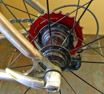
It works fine with the Shimano Dura-Ace chain. And shifts beautifully with a (satisfying?) clunk. The weight savings is several orders of magnitude below any measureable threshold since I'm weighing in at 70kg plus. And in any case, I need a slightly longer (and heavier) chain. The 26T, however, is the reason why I bought it. My legs can appreciate the slightly over 10% easier climbing it brings at the same cadence.
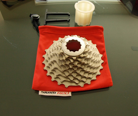
(See last entry on the matter here.) However, recognizing that I no longer had the legs to ride a 23T up Mt Lemmon (even on a compact crank setup), I installed an SRAM Red 11-26 cassette this weekend. And it immediately took me back to my bike porn days. I grabbed my DSLR to illustrate why before it got all greasy and encrusted with dirt:
Not only that it's a specially-made 10-speed steel cassette that is hollowed out to the point it weighs just 168g as measured on my scale (see below) but the fact that it comes in a (function-free) soft red bag is proof-positive this is a serious piece of chi-chi componentry.
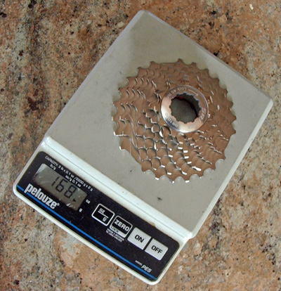
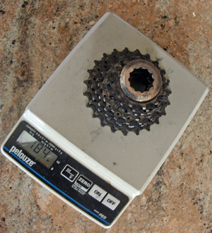
Lightweight backpackers can probably appreciate that 168g is amazing light for all steel construction, especially when compared to a narrower range Shimano Dura-Ace 12-23 cassette with a mix of steel and titanium cogs riding on alloy carriers that weighs 184g on the same scale:
Functionality-wise, it's a direct drop in. Only sign I have it is the relatively subtle red plate on the back:
It works fine with the Shimano Dura-Ace chain. And shifts beautifully with a (satisfying?) clunk. The weight savings is several orders of magnitude below any measureable threshold since I'm weighing in at 70kg plus. And in any case, I need a slightly longer (and heavier) chain. The 26T, however, is the reason why I bought it. My legs can appreciate the slightly over 10% easier climbing it brings at the same cadence.
Monday, August 25, 2008
Another tri-state area
When one hear the term Tri-State Area or Region, I believe most people think of the well-known New York-New Jersey-Connecticut (NY-NJ-CT) tri-state region. Well, at least the two are synonymous for me probably because I've spent ten years living in Jersey.
Of course, other tri-state areas exist but I was astonished to discover there are actually as many as 38 officially-marked "tripoints" in the United States. Moreover, the NY-NJ-CT tri-state region does not actually possess a tripoint. (See this authoritative Wikipedia entry.)
Last week, I visited one of these real tripoints on my drive home from Boston to Tucson. As seen on my iPhone 3G map display, this is where Virgina, Tennessee and Kentucky meet. (The blue GPS blob marks the point where I was standing.)

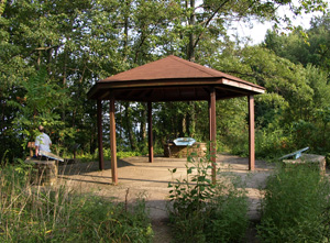
Although it's a nice 1.2 mile walk up to the Tri-State Peak located inside the Cumberland Gap National Historical Park, it's a bit of a disappointing hike: trees and other vegetation block any chance of a scenic view.
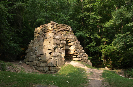
Nestled in a clearing lower down, however, is the surprisingly photogenic (almost Mayan temple-like) remains of an Iron Furnace:
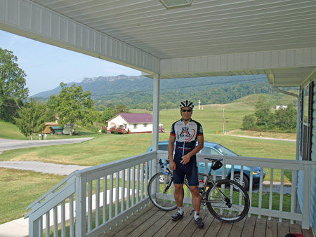
Given my recent interest in 360° spherical panorama photography (see recent blog entry tech and subjects: The Stata Center and The Getty Museum Los Angeles), I couldn't resist the opportunity to make a panorama at this spot. Download here. (Warning: 12.1MB file. You can view this using Quicktime player.) Anyway, I was here to visit my good friend Jim Montgomery who has recently moved to this hilly and very rural - let's just say dining-opportunity-limited - corner of southwestern Virigina bordering Kentucky and Tennessee. The upsides are the gorgeous scenery and almost empty roads in pristine condition (a consequence of the lack of real winter, population and truck traffic I reckon). In short, a perfect "secret" location for bike training. On Jim's porch:
jim led me on a perfect 25 mile training loop from his home in Rose Hill VA with about 1700 ft of climbing. The GPS tracklog recorded on my Garmin eTrex Vista Cx:

I wish I had more time to explore the region on my bike but the start of a new semester in Tucson cannot be delayed. For example, the Cumberland Gap tunnel "crosses" - or is it also appropriate to use the semantically-bleached terms "bridge" or "thread"? - the mountain ridge that can be seen in the background. In particular, I'd like to try the (presumably abandoned) mountain road it replaced. Another Wikipedia entry states:
Although it's a nice 1.2 mile walk up to the Tri-State Peak located inside the Cumberland Gap National Historical Park, it's a bit of a disappointing hike: trees and other vegetation block any chance of a scenic view.
Nestled in a clearing lower down, however, is the surprisingly photogenic (almost Mayan temple-like) remains of an Iron Furnace:
Given my recent interest in 360° spherical panorama photography (see recent blog entry tech and subjects: The Stata Center and The Getty Museum Los Angeles), I couldn't resist the opportunity to make a panorama at this spot. Download here. (Warning: 12.1MB file. You can view this using Quicktime player.) Anyway, I was here to visit my good friend Jim Montgomery who has recently moved to this hilly and very rural - let's just say dining-opportunity-limited - corner of southwestern Virigina bordering Kentucky and Tennessee. The upsides are the gorgeous scenery and almost empty roads in pristine condition (a consequence of the lack of real winter, population and truck traffic I reckon). In short, a perfect "secret" location for bike training. On Jim's porch:
jim led me on a perfect 25 mile training loop from his home in Rose Hill VA with about 1700 ft of climbing. The GPS tracklog recorded on my Garmin eTrex Vista Cx:
I wish I had more time to explore the region on my bike but the start of a new semester in Tucson cannot be delayed. For example, the Cumberland Gap tunnel "crosses" - or is it also appropriate to use the semantically-bleached terms "bridge" or "thread"? - the mountain ridge that can be seen in the background. In particular, I'd like to try the (presumably abandoned) mountain road it replaced. Another Wikipedia entry states:
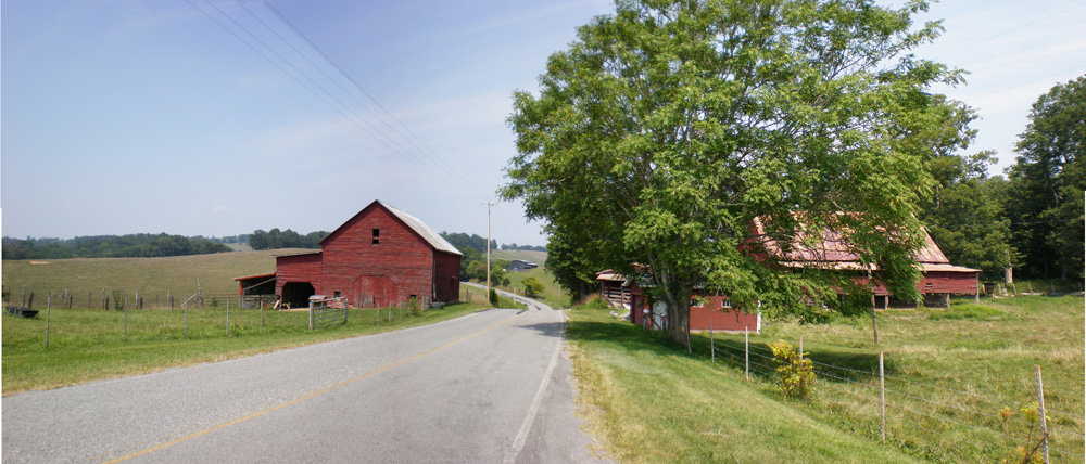
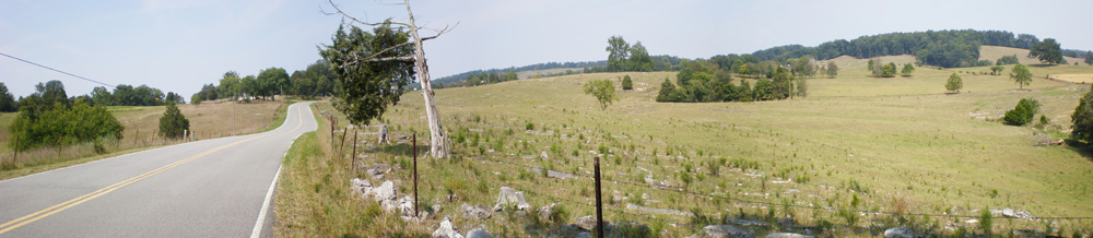
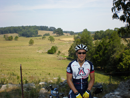
The tunnel replaced a 2.3-mile (3.7 km) stretch of U.S. 25E between Middlesboro, Kentucky and Cumberland Gap, Tennessee that became known as "Massacre Mountain" due to the large number of travelers killed on the twisting mountain road over the Cumberland Gap pass.Anyway, some pictures from the ride are shown below - I'd have to rate the route as equal or better to my favorite Valley Forge PA area hill route I used to ride but without the traffic and with far better roads.
Friday, November 2, 2007
Back on the bike
Tomorrow, I'm doing 200km brevet ride from Marana to the top of Mt Lemmon and back. 125 miles.
So today, I put the bike back together again. It has been lying in my living room in pieces for months. I've been so busy since the start of the semester in mid-August, I can't believe it's November before I'm actually riding again.
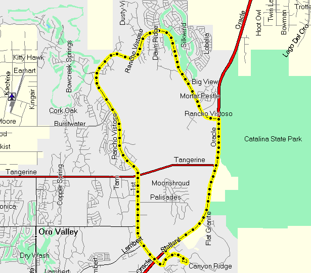 SRM:
SRM:
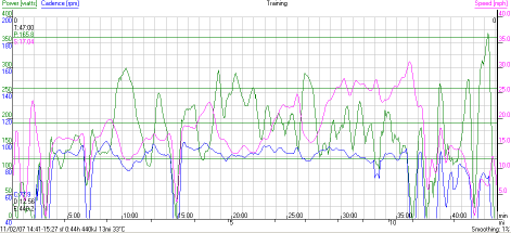
I see I pushed the wattage close to 400W near the end. Couldn't resist. It's good to be back on the bike.
- First, I degreased and washed it. Charged the dead SRM PC V controller while I did all this.
- Threaded in a shiny new Shimano Dura-Ace 9-speed chain, my last one. Push the pin in. Break it off carefully. No more pins left, gotta get some spares.
- Installed new rear Michelin Pro Race2 tire (old one ruined on too-fresh tarmac in Delaware). New rear brake pads (Swissstop yellow) for the Reynolds Stratus carbon clincher rear wheel. Adjust the rear brake and pads.
- Swap the touring seatpost/saddle for the regular one (Selle Italia SLR and Bold Precision Ti seatpost). It's actually identical to the touring one except for the Moots Ti seatrack. Mount the underseat Blackburn bag with tools, 2 CO2 cartridges, Park patches and inflator.
- Put the fork back in. Adjust headset preload. Line up saddle nose, stem and fork. Put the Keywin pedals back in. Tighten cleat bolts on my shoes. Tighten waterbottle bolts.
- New stem mount system for the Garmin Vista Cx. Reset ascent, tracklog, and trip on the Garmin. It has been a while. Almost forgot how to do it.
- Connect PC V to Windows XP. Set the new date/time. Mount it on the bike. Hit Set + Mode to set the offset. So much stuff to remember. Get dressed.
I see I pushed the wattage close to 400W near the end. Couldn't resist. It's good to be back on the bike.
Friday, June 29, 2007
The Pleasure of Cycling
|
Yesterday, I went for a simple 35 mile with my friend Jim Montgomery in Maryland (adjoining Delaware).
We did 14 miles to the town of North East in Maryland. Billiard-board smooth roads.
Had lunch at Woody's Crab House. Famous for blue crabs from Chesapeake Bay. |

|
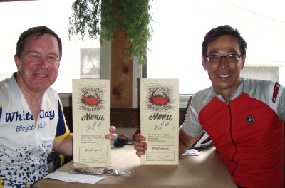 Average speed under 15mph. Maybe 1000 kcal. Jim wanted the ride stats, but I really didn't care.
Back to the fundamentals. The pleasure of pedaling a responsive, custom-fit race machine. Enjoying the beautiful back country roads on a sunny day with a good friend. Moving along effortlessly, this is the way cycling is meant to be.
Perhaps I am mellowing, but if I had just one ride left and had to choose: the Elite Southern Transcontinental (I just completed), or one lazy summer's day with friends, Lazy wins out every time.
Fortunately, I don't have to choose :-)
Similar thoughts hit me during the last two weeks
Average speed under 15mph. Maybe 1000 kcal. Jim wanted the ride stats, but I really didn't care.
Back to the fundamentals. The pleasure of pedaling a responsive, custom-fit race machine. Enjoying the beautiful back country roads on a sunny day with a good friend. Moving along effortlessly, this is the way cycling is meant to be.
Perhaps I am mellowing, but if I had just one ride left and had to choose: the Elite Southern Transcontinental (I just completed), or one lazy summer's day with friends, Lazy wins out every time.
Fortunately, I don't have to choose :-)
Similar thoughts hit me during the last two weeks
I was toying with several hypothetical situations during some of the more boring miles of the Transcontinental. One of them goes something like this.
If someone said to me: "Sandiway, you can quit your job. All you have to do is ride 100 miles before lunch every day. You can do whatever you want (in addition) after lunch but you have to put in those 100 miles first," would I do it?
The answer is emphatically NO. I love cycling but I guess I'm just not RAAM material.
Sunday, June 3, 2007
Kitt Peak climb
Kitt Peak is one of two climbs around Tucson that I really like.
(The other area climb is Mt Lemmon, see earlier blog entry here.)
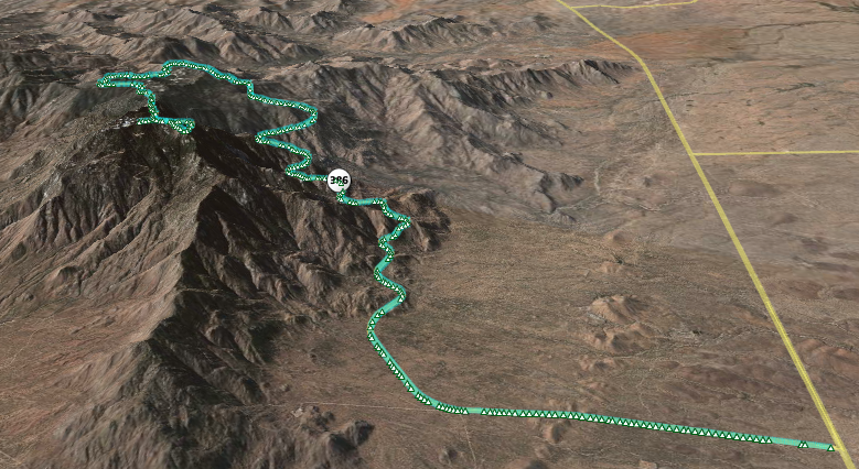
Here is the GPS tracklog from the Magellan eXplorist 600 plotted on Google Earth:
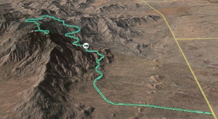
{Click on the picture for a larger image.] As you can see, the 12 mile road to the observatories at the top rises gently at first. A right hander, then it starts climbing properly. An excellent test of fitness. It took me 1:30, which means I lost considerable bike-specific fitness during my travels despite running and swimming nearly every day. No faking out the mountain. Brutually revealing. 1:15 would have been a good time (for me). The bumpy descent (20 mins) turned out also to be a good test of the Magellan GPS receiver. It switched off by itself on the descent. The tracklog shown above is from the climb.
Update: Unfortunately, the eXplorist 600 seems hosed. Have to send it back to Magellan to see if it can be repaired. With PacTour Elite Transcontinental only one week away, that's not enough time, plus it's already way out of warranty. I ordered a Garmin Vista Cx on Monday. Hope to get it Wednesday.
|
Specs?
12 miles, climbing 3560 ft (1085m). Dead end road (built to transport massive telescopes) tops out at 6795 ft (2071m). |
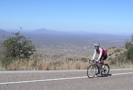
[Photo courtesy of Jim Montgomery.] |
{Click on the picture for a larger image.] As you can see, the 12 mile road to the observatories at the top rises gently at first. A right hander, then it starts climbing properly. An excellent test of fitness. It took me 1:30, which means I lost considerable bike-specific fitness during my travels despite running and swimming nearly every day. No faking out the mountain. Brutually revealing. 1:15 would have been a good time (for me). The bumpy descent (20 mins) turned out also to be a good test of the Magellan GPS receiver. It switched off by itself on the descent. The tracklog shown above is from the climb.
Update: Unfortunately, the eXplorist 600 seems hosed. Have to send it back to Magellan to see if it can be repaired. With PacTour Elite Transcontinental only one week away, that's not enough time, plus it's already way out of warranty. I ordered a Garmin Vista Cx on Monday. Hope to get it Wednesday.
Sunday, May 13, 2007
Mt Lemmon: climb to Ski Valley
Sometimes I forget, but there is a world-class road climb right on the edge of town.
It's called Catalina Highway and it climbs Mt Lemmon.
Stats? Start at the intersection of Tanque Verde and Catalina Highway (alt: 2550 ft, 778m).
It tops out in Ski Valley (alt: 8350 ft, 2546m). A bit over 30 miles long. A (5800 ft, 1768m) climb. Looking to go under the 3 hour mark with moderate fitness, under 2:30 if in real shape.
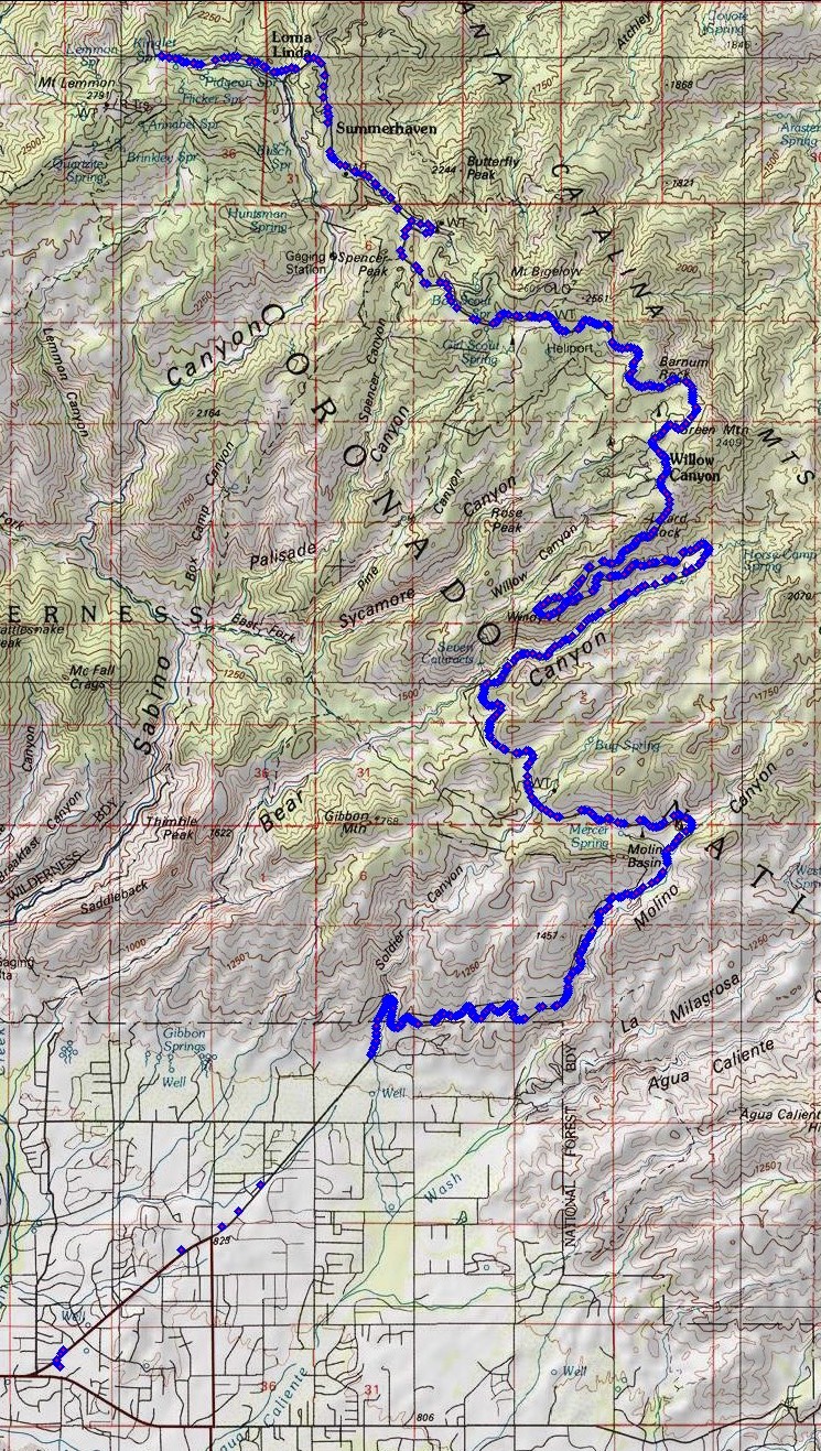
See the GPS route plotted on Google Earth:
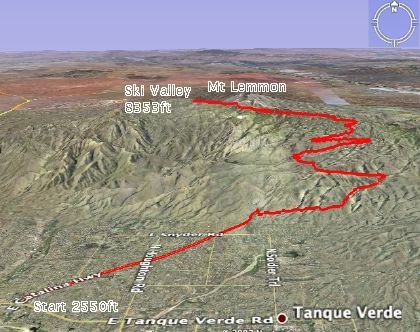
{Click here for a larger image.] See the GPS waypoints plotted on National Geographic Topo!: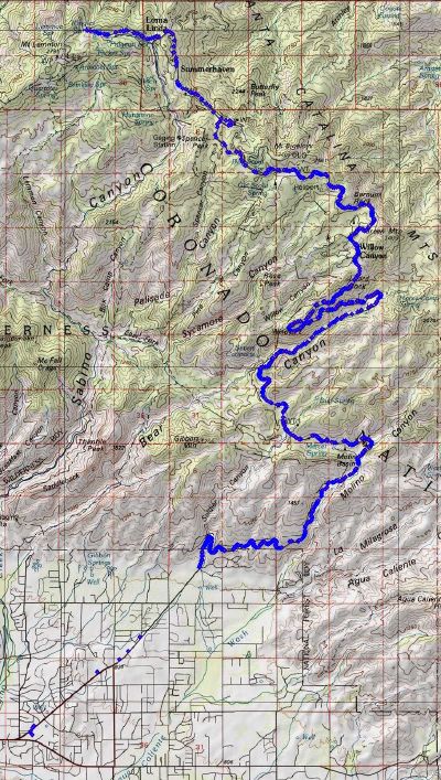
{Click here for a larger image.] In summer, the temperature in Tucson regularly reaches 40C (over 100F). Climbing Mt Lemmon can make sense in this heat. Start early in the morning, say 7:30am when the temperature is in the 20s (70sF). When the temperature reaches 40C, you will be at the top of the mountain where the temperature is likely to be 23C. Unfortunately, this year travel and catch-up when home have taken their toll on bike fitness no matter how much I swim and run. But with a major event coming soon in June, I need to see where I am on the fitness curve. So today, I climbed to Ski Valley and had a late breakfast at the Iron Door restaurant.
Here are some of the checkpoints and baseline fitness marks I use. I carried 60oz of water, just enough to not need refilling.
Tech:
{Click here for a larger image.] See the GPS waypoints plotted on National Geographic Topo!:
{Click here for a larger image.] In summer, the temperature in Tucson regularly reaches 40C (over 100F). Climbing Mt Lemmon can make sense in this heat. Start early in the morning, say 7:30am when the temperature is in the 20s (70sF). When the temperature reaches 40C, you will be at the top of the mountain where the temperature is likely to be 23C. Unfortunately, this year travel and catch-up when home have taken their toll on bike fitness no matter how much I swim and run. But with a major event coming soon in June, I need to see where I am on the fitness curve. So today, I climbed to Ski Valley and had a late breakfast at the Iron Door restaurant.
 |
 |
| Named Section |
(Approx) Mile marker |
Notes |
| Warm-up | 4.5 miles (up to mile marker 0) | Straight and relatively flat before entering the Coronado National Forest. |
| Windy Point Vista | mile marker 14 | Almost halfway. About 6000ft up. Baseline Timecheck: 1:50 (hr:mins). Turn back here if fitness has deserted you. |
| Summerhaven | mile marker 25 | Turn right to keep climbing to Ski Valley.
Baseline Timecheck: 2:50 (hr:mins) |
| Ski Valley | mile marker 27 | Steepest section of the road to the top. Irondoor restaurant at Ski Valley. Ski lift can take you to 9157ft (2791m).
Baseline Timecheck: 3:00 (hr:mins) |
| I used a small Magellan eXplorist 600 GPS receiver mounted on the handlebar stem. The eXplorist has a USB interface which allows the device to appear like a hard drive to the computer. Files can be simply copied off the device for processing. It records a tracklog, each line of which looks something like: |  |
$PMGNTRK,3215.545,N,11047.879,W,00778,M,142226.79,A,,130507*61
The Magellan file format has to be converted into KML (Keyhole Markup Language) for Google Earth. GPSBabel+ is free software that can do this automatically.
For National Geographic Topo!, I reformat the lat/long fields slightly (as shown below) and import directly via the Wizard.
$PMGNTRK,32.15545,N,110.47879,W,00778,M,142226.79,A,,130507*61
Subscribe to:
Posts (Atom)